Map Making as Story and Instruction
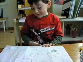
Listen to the child’s explanation of his map. His uses his map as a hybrid of storyboard and spatial notation. For example, the three rocks on 8th Street become the protagonist in the child’s story. They serve as a spatial point of reference, a challenge for breaking through them, an obstacle to hurdle to get across the empty space on the map to the closest street mark, and something that is known only to people who have actually been “on” 8th Street.
He knows the difference between story and map. At one point he says, “That’s not in real life,” in reference to a path through the rocks. He enjoys the teacher’s interest in both the map and the story, saying, “I know some tricks,” after explaining how one can jump over the rocks to get to the next street and eventually to where he lives.
Of particular interest is the child’s understanding of shared perspective. One would not know of the three rocks on 8th Street unless one had actually been on Spruce Street (which in reality is a cross street to 8th in Boulder where he lives). He also makes a distinction between information that is deliberately withheld (a secret) and information that is simply unfamiliar (lack of experience). To the teacher’s question about the rocks, “It is a secret?” the child replies, “No, but you just don’t know because you have never been to Spruce Street.”
For another notable moment, consider this child’s delight in using his map as a way to get back to where he started. This concept has a complexity that merits pause. Think about the paradox of one spot being both a beginning and an ending. The shift from linear thinking to cycles is a huge advance in children’s thinking as it has been in science. Children intuitively recognize this paradox and treat it as special.
The child’s conversation about his map indicates that he knows objects have location, that is, proximity matters. Listen as he explains, “The Journey School is not on Spruce Street.” He understands that the teacher did not know what his house mark meant when the teacher asked, “Is that the Journey School?” But instead of saying, “No, that does not look like the Journey School,” he gave a location to distinguish the symbol. Maps are primarily about location rather than specific forms, and the child understands that.
We can confidently conclude that the child’s marks represent the spatial layout of real objects drawn to instruct one to know how to get around. The marks do more than represent how a generic object looks, such as drawing a generalized house or even a conventional playground. The child drew his map with the intent to help someone navigate passage from the rocks to his house, (e.g. “There’s a path through the rocks.”).
It is true that his marks are curves and not the Euclidean (straight lines and angles) grid of the Boulder streets. Nevertheless, the marks are meant to be read as paths that instruct one on what direction to move. The marks have a procedural intent and not simply a pictorial or declarative intent. The fact that they are curves does not destroy the power of his symbols to capture what is connected and what is not connected. These topological attributes of connection and continuity are often understood as a stage earlier than the Euclidean attributes of straight lines and angles. The quantitative attributes of length and proportion of lines will come later. You see a budding interest in length when the child says, “Spruce Street is very little. Spruce Street is only this long. ” From these qualitative concepts, quantitative concepts of scale and measured length grow.